Saturday, October 30, 2010

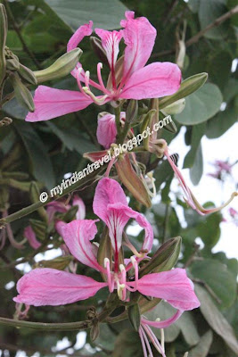
Flowering Tree - Bauhinia Variegata

Bangalore (State: Karnataka) known as Garden City true to its name as lot of flowering trees on either side of most of the roads. They bloom with flowers of various colors. One such tree is Bauhinia Variegata popularly known as "Orchid Tree" (Click on the images for bigger view)

It is an ornamental tree grown in subtropical and tropical climates from southern China west to India. The flowers are conspicuous, bright pink or white, 8-12 cm diameter. These scented flowers have only five petals.

It is a small to medium-sized tree growing to 10-12 m tall. The leaves of the tree are broad and split in the middle.

During the season the tree is full of flowers and with green leaves and pink flowers they look lovely.

[Read Posts...]

Friday, October 29, 2010

Komodo National Park, Indonesia


Komodo National Park lies in the Wallacea Region of Indonesia, identified by WWF and Conservation International as a global conservation priority area. The Park is located between the islands of Sumbawa and Flores at the border of the Nusa Tenggara Timur (NTT) and Nusa Tenggara Barat (NTP) provinces. It includes three major islands, Komodo, Rinca and Padar, and numerous smaller islands together totaling 603 km2 of land. The total size of Komodo National Park is presently 1,817 km2. Proposed extensions of 25 km2 of land (Banta Island) and 479 km2 of marine waters would bring the total surface area up to 2,321 km2. (Click on the map to enlarge - 70kB)


Komodo National Park was established in 1980 and was declared a World Heritage Site and a Man and Biosphere Reserve by UNESCO in 1986. The park was initially established to conserve the unique Komodo dragon (Varanus komodoensis), first discovered by the scientific world in 1911 by J.K.H. Van Steyn. Since then conservation goals have expanded to protecting its entire biodiversity, both marine and terrestrial.

The majority of the people in and around the Park are fishermen originally from Bima (Sumbawa), Manggarai, South Flores, and South Sulawesi. Those from South Sulawesi are from the Suku Bajau or Bugis ethnic groups. The Suku Bajau were originally nomadic and moved from location to location in the region of Sulawesi, Nusa Tenggara and Maluku, to make their livelihoods. Descendents of the original people of Komodo, the Ata Modo, still live in Komodo, but there are no pure blood people left and their culture and language is slowly being integrated with the recent migrants.

Little is known of the early history of the Komodo islanders. They were subjects of the Sultanate of Bima, although the island’s remoteness from Bima meant its affairs were probably little troubled by the Sultanate other than by occasional demand for tribute.

There are presently almost 4,000 inhabitants living within the park spread out over four settlements (Komodo, Rinca, Kerora, and Papagaran). All villages existed prior to 1980 before the area was declared a national park. In 1928 there were only 30 people living in Komodo Village, and approximately 250 people on Rinca Island in 1930. The population increased rapidly, and by 1999, there were 281 families numbering 1,169 people on Komodo, meaning that the local population had increased exponentially. Komodo Village has had the highest population increase of the villages within the Park, mostly due to migration by people from Sape, Manggarai, Madura, and South Sulawesi. The number of buildings in Kampung Komodo has increased rapidly from 30 houses in 1958, to 194 houses in 1994, and 270 houses in 2000. Papagaran village is similar in size, with 258 families totaling 1,078 people. As of 1999, Rinca’s population was 835, and Kerora's population was 185 people. The total population currently living in the Park is 3,267 people, while 16,816 people live in the area immediately surrounding the Park.

The average level of education in the villages of Komodo National Park is grade four of elementary school. There is an elementary school located in each of the villages, but new students are not recruited each year. On average, each village has four classes and four teachers. Most of the children from the small islands in the Kecamatan Komodo (Komodo, Rinca, Kerora, Papagaran, Mesa) do not finish elementary school. Less than 10% of those which do graduate from elementary school will continue to high school since the major economic opportunity (fishing) does not require further education. Children must be sent to Labuan Bajo to attend high school, but this is rarely done in fishermen’s families.

Most of the villages located in and around the Park have few fresh water facilities available, if any, particularly during the dry season. Water quality declines during this time period and many people become ill. Malaria and diarrhea are rampant in the area. On Mesa island, with a population of around 1,500 people, there is no fresh water available. Fresh water is brought by boat in jerrycans from Labuan Bajo. Each family needs an average of Rp 100,000.- per month to buy fresh water (2000). Almost every village has a local medical facility with staff, and at least a paramedic. The quality of medical care facilities is low.

Traditional Customs: Traditional communities in Komodo, Flores and Sumbawa have been subjected to outside influences and the influence of traditional customs is dwindling. Television, radio, and increased mobility have all played a part in accelerating the rate of change. There has been a steady influx of migrants into the area. At the moment nearly all villages consist of more than one ethnic group.

Religion: The majority of fishermen living in the villages in the vicinity of the Park are Muslims. Hajis have a strong influence in the dynamics of community development. Fishermen hailing from South Sulawesi (Bajau, Bugis) and Bima are mostly Moslems. The community from Manggarai are mostly Christians.

Anthropology and Language: There are several cultural sites within the Park, particularly on Komodo Island. These sites are not well documented, however, and there are many questions concerning the history of human inhabitance on the island. Outside the Park, in Warloka village on Flores, there is a Chinese trading post remnant of some interest. Archeological finds from this site have been looted in the recent past. Most communities in and around the Park can speak Bahasa Indonesia. Bajo language is the language used for daily communication in most communities.


Topography: The topography is varied, with slopes from 0 – 80%. There is little flat ground, and that is generally located near the beach. The altitude varies from sea level to 735 m above sea level. The highest peak is Gunung Satalibo on Komodo Island.

Geology: The islands in Komodo National Park are volcanic in origin. The area is at the juncture of two continental plates: Sahul and Sunda. The friction of these two plates has led to large volcanic eruptions and caused the up-thrusting of coral reefs. Although there are no active volcanoes in the park, tremors from Gili Banta (last eruption 1957) and Gunung Sangeang Api (last eruption 1996) are common. West Komodo probably formed during the Jurasic era approximately 130 million years ago. East Komodo, Rinca, and Padar probably formed approximately 49 million years ago during the Eocene era.

Climate: Komodo National Park has little or no rainfall for approximately 8 months of the year, and is strongly impacted by monsoonal rains. High humidity levels year round are only found in the quasi-cloud forests on mountain tops and ridges. Temperatures generally range from 170C to 340C, with an average humidity level of 36%. From November through March the wind is from the west and causes large waves that hit the entire length of Komodo island’s west beach. From April through October the wind is dry and large waves hit the south beaches of Rinca and Komodo islands.


The terrestrial ecosystems are strongly affected by the climate: a lengthy dry season with high temperatures and low rainfall, and seasonal monsoon rains. The Park is situated in a transition zone between Australian and Asian flora and fauna. Terrestrial ecosystems include open grass-woodland savanna, tropical deciduous (monsoon) forest, and quasi cloud forest.

Due to the dry climate, terrestrial plant species richness is relatively low. The majority of terrestrial species are xerophytic and have specific adaptations to help them obtain and retain water. Past fires have selected for species that are fire-adapted, such as some grass species and shrubs. Terrestrial plants found in Komodo National Park include grasses, shrubs, orchids, and trees. Important food tree species for the local fauna include Jatropha curkas, Zizyphus sp., Opuntia sp., Tamarindus indicus, Borassus flabellifer, Sterculia foetida, Ficus sp., Cicus sp., ‘Kedongdong hutan’ (Saruga floribunda), and ‘Kesambi’ (Schleichera oleosa).


The terrestrial fauna is of rather poor diversity in comparison to the marine fauna. The number of terrestrial animal species found in the Park is not high, but the area is important from a conservation perspective as some species are endemic.. Many of the mammals are Asiatic in origin (e.g., deer, pig, macaques, civet). Several of the reptiles and birds are Australian in origin. These include the orange-footed scrubfowl, the lesser sulpher-crested cockatoo and the nosy friarbird.

Reptiles: The most famous of Komodo National Park's reptiles is the Komodo Dragon (Varanus komodoensis). It is among the world's largest reptiles and can reach 3 meters or more in length and weigh over 70kg. To find out more about this fascinating creature click here.

Other than the Komodo Dragon twelve terrestrial snake species are found on the island. including the cobra (Naja naja sputatrix), Russel’s pit viper (Vipera russeli), and the green tree vipers (Trimeresurus albolabris). Lizards include 9 skink species (Scinidae), geckos (Gekkonidae), limbless lizards (Dibamidae), and, of course, the monitor lizards (Varanidae). Frogs include the Asian Bullfrog (Kaloula baleata), Oreophyne jeffersoniana and Oreophyne darewskyi. They are typically found at higher, moister altitudes.

Mammals: Mammals include the Timor deer (Cervus timorensis), the main prey of the Komodo dragon, horses (Equus sp.), water buffalo (Bubalus bubalis), wild boar (Sus scrofa vittatus), long-tailed macaques (Macaca fascicularis), palm civets (Paradoxurus hermaphroditus lehmanni), the endemic Rinca rat (Rattus rintjanus), and fruit bats. One can also find goats, dogs and domestic cats.

Birds: One of the main bird species is the orange-footed scrub fowl (Megapodius reinwardti), a ground dwelling bird. In areas of savanna, 27 species were observed. Geopelia striata and Streptopelia chinensis were the most common species. In mixed deciduous habitat, 28 bird species were observed, and Philemon buceroides, Ducula aenea, and Zosterops chloris were the most common.


The marine area constitutes 67% of the Park. The open waters in the Park are between 100 and 200 m deep. The straits between Rinca and Flores and between Padar and Rinca, are relatively shallow (30 to 70 m deep), with strong tidal currents. The combination of strong currents, coral reefs and islets make navigation around the islands in Komodo National Park difficult and dangerous. Sheltered deep anchorage is available at the bay of Loh Liang on Komodo’s east coast, the South East coast of Padar, and the bays of Loh Kima and Loh Dasami on Rinca.

In the North of the Park water temperature ranges between 25 – 29°C. In the middle, the temperature ranges between 24 and 28°C. The temperatures are lowest in the South, ranging from 22 – 28°C. Water salinity is about 34 ppt and the water is quite clear, although the waters closer to the islands are relatively more turbid.


Indonesia is the only equatorial region in the world where there is an exchange of marine flora and fauna between the Indian and Pacific oceans. Passages in Nusa Tenggara (formerly the Lesser Sunda Islands) between the Sunda and Sahul shelves allow movement between the Pacific and Indian oceans. The three main ecosystems in Komodo National Park are seagrass beds, coral reefs, and mangrove forests. The Park is probably a regular cetacean migration route.


The three major coastal marine plants are algae, seagrasses and mangrove trees. Algae are primitive plants, which do not have true roots, leaves or stems. An important reef-building algae is the red coralline algae, which actually secretes a hard limestone skeleton that can encrust and cement dead coral together. Seagrasses are modern plants that produce flowers, fruits and seeds for reproduction. As their name suggests, they generally look like large blades of grass growing underwater in sand near the shore. Thallasia sp. and Zastera spp. are the common species found in the Park. Mangroves trees can live in salty soil or water, and are found throughout the Park. An assessment of mangrove resources identified at least 19 species of true mangroves and several more species of mangrove associates within the Park's borders.


Komodo National Park includes one of the world's richest marine environments. It consists of forams, cnidaria (includes over 260 species of reef building coral), sponges (70 species), ascidians, marine worms, mollusks, echinoderms, crustaceans, cartilaginous and bony fishes (over 1,000 species), marine reptiles, and marine mammals (dolphins, whales, and dugongs). Some notable species with high commercial value include sea cucumbers (Holothuria), Napoleon wrasse (Cheilinus undulatus), and groupers.


While most visitors enter Komodo National Park (KNP) through the gateway cities of Labuan Bajo in the west of Flores or Bima in eastern Sumbawa, the departure point for your trip is actually Denpasar, Bali.

How to get there ?

By Air:
Indonesia Air Transport (IAT)
Depart : Everyday
DPS - LBJ : 10.00 – 11.30
LBJ - DPS : 12.00 – 13.30

Price:
Y CLASS : IDR 751.000
H CLASS : IDR 696.000
Q CLASS : IDR 641.000 (NON REFUND TICKET)

Trans Nusa Airlines (TGN)
Depart : Everyday
DPS – LBJ : 10.00 – 11.50 & 13.00 – 14.20
LBJ – DPS VIA BMU (BIMA) : 12.05 - 12.35
BMU-DPS : 12.50 – 13.45
LBJ – DPS : 14.35 – 15.15

Price
Y CLASS : IDR 761.000
L CLASS : IDR 651.000
M CLASS : IDR 541.000

By Land:
The gateway cities of Labuan Bajo and Bima are connected to Denpasar, Bali by overland buses.

By Sea (ferry):
Travel time: approximately 36 hours
The gateway cities of Labuan Bajo and Bima are also connected to Denpasar, Bali by inter-island ferry.

Contact the Indonesia Sea Transportation Company (PELNI) at Jalan Raya Kuta No. 299, Tuban - Bali (Tel: 0361 - 763 963) to reserve a seat on the KM. Tilong Kabila, which departs Benoa Port, Bali bound for Bima and Labuan Bajo

Benoa-Bima-Labuan Bajo
Fortnightly (every two weeks) on Saturdays: 09.00-20.00 (next day).
One-way ticket (as of 10/6/06) from Rp. 143,000.00 - Rp. 435,000.00

Labuan Bajo-Bima-Benoa
Fortnightly (every two weeks) on Thursdays: 08.00-11.00 (next day).
One-way ticket (as of 10/6/06) from Rp. 143,000.00 - Rp. 435,000.00
Note: the ferry schedule and ticket prices may change with or without prior notice

By Sea (live-aboard):
Komodo National Park is serviced by a wide range of live-aboard boats, with return packages to Komodo National Park from a variety of departure points, including Bali, Lombok, Bima and Labuan Bajo
Prices (as of 10/6/06) are ranging from USD 230.00 - USD 295.00 / person / night.

From Gateway Cities to Komodo National Park (KNP)

You can easily organize a shared boat charter by local boat from either ports at Labuan Bajo or Bima (Sape) to the two major points of access in the Park: Loh Liang (on Komodo Island) or Loh Buaya (on Rinca Island)
Charter price (as of 10/6/06) - excluding meals, KNP entrance fee etc:
Labuan Bajo: KNP: Rp. 750,000 - 1,500,000 per boat / day
Bima (Sape): KNP: Rp. 1,500.000 - 2,000.000 per boat / day
"Note: the charter prices may change with or without prior notice"

For more information please contact:

=]

Komodo Marine National Park Office
Jl. Kasimo Labuan Bajo
West Flores, East Nusa Tenggara 86445
Ph. +62 385 41004 Fax. +62 385 41006
e-mail: tnkomodo@indosat.org

PT Putri Naga Komodo
Bali: Jl. Pengembak No.2 Sanur 80228, Bali T: +62 381 780 2408 F: +62 361 747 4398
Labuan Bajo: Gg.Masjid, Kampung Cempa. Labuan Bajo, 86554 West Manggarai. East Nusa Tenggara. T: +62 385 41448 F: +62 385 41225
E-mail: info@putrikomodo.com Website: www.komodonationalpark.org / www.gokomodo.org


[Read Posts...]

Thursday, October 28, 2010

Era of payphones ends in Estonia on December 1

The era of payphones ends in Estonia on December 1, 2010. AS Elion, who owns the payphones that haven’t been dismantled yet, withdraws payphone cards from sale on October 15. The last call from a payphone can be made on November 30.

“We will start dismantling payphones on December 1. We are ready to give them for example to artists if they want to make installations of payphones, for example,” said Elion’s PR head Lilian Nõlvak.

“The payphone business is loss-making and unpopular among clients. The number of calls fell from 2004 by nearly 30 times,” she added.

In 1997 when the installation of modern payphones using chip cards was completed, there were 3,000 of them in Estonia. By now there are just about 550, most of them in Tallinn.

While in 2004 still 6 million minutes worth of calls were made from payphones, now it is 30 times smaller due to the wide spread of cell phones. The annual sales volume of payphone call cards has fallen by 20 time since 2004.

source:
http://www.baltic-course.com/
[Read Posts...]

Wednesday, October 27, 2010

Meharangarh Fort, Jodhpur

The Fort of Jodhpur (State: Rajasthan) looms on the top of a rocky hill, and it rises 125 mts, above the plains. Built in the 15th century by the Rathore Rajputs, the architecture is such that, one can not separate the fort from bluff-colored sandstone hill on which it is constructed. (Click on the images for bigger view)

The fort is built on the hill in such a way that it is very difficult to identify where
the hill ends and the fort walls begin. The fort at several places has 17 feet thick and 68 feet high walls.

It is approached by a series of 7 gateways set at an angle so that armies could not charge them with any success. Past the gates, the fort-palace takes one's breath away.


Across from huge courtyards are the palatial apartments that have been built over five centuries of bristling history. The beauty and the grandeur of numerous palaces in the fort narrates a saga of hard sandstones yielding to the chisels of skilled craftsmanship. Only some of the spectacular palaces of the fort are open to the visitors.

These consists of Moti Mahal with its pierced screen windows overlooking the coronation seat where the Rathore ruler have been ritually anointed to rule; Jhanki Mahal, the apartment from where the zenana women would watch ceremonial
events; Chandan Mahal, where affairs of state were discussed; the royal Darbar Takhat or throne room with its octagonal throne.

[Read Posts...]

Petronas Twin Towers Malaysia

BUILDING BIG: Databank: Petronas Towers
Until 1998, the world's tallest skyscraper had always been in the United States. But that year, Malaysia's Petronas Towers laid claim to this distinction. ...
www.pbs.org/wgbh/buildingbig/.../petronas_towers.html

Petronas Towers — Infoplease.com
Petronas Towers, twin skyscrapers in Kuala Lumpur, Malaysia, ... The twin towers house Petronas, Malaysia's government-owned oil company, ...
www.infoplease.com/ce6/world/A0909775.html

Malaysia Petronas Towers photo gallery - 30 high quality pictures ...
The Petronas Twin Towers in Kuala Lumpur, named after the Malaysian Petronas industrial group, were the world's tallest building between 1998 and 2004. ...
www.molon.de/galleries/Malaysia/KL/Petronas/

Petronas Twin Towers Malaysia

Petronas Twin Towers Malaysia
http://greenstructures.wordpress.com/2009/08/12/top-five-tallest-buildings/

The Petronas Twin Towers (Malay: Menara Berkembar Petronas) (also known as the Petronas Towers or just Twin Towers), in Kuala Lumpur, Malaysia are twin towers and were the world's tallest buildings before being surpassed by Taipei 101. However, the towers are still the tallest twin buildings in the world. They were the world's tallest buildings from 1998 to 2004 if measured from the level of the main entrance to the structural top, the original height reference used by the international organization Council on Tall Buildings and Urban Habitat from 1969 (three additional height categories were introduced as the tower neared completion in 1996).

Comparison with other towers

In accordance to CTBUH, the pinnacles contributed to the overall height of the towers, thus surpassing the Willis Tower.

The Petronas Twin Towers were the tallest buildings in the world until Taipei 101 was completed in 2004, as measured to the top of their structural components (spires, but not antennas).Spires are considered integral parts of the architectural design of buildings, to which changes would substantially change the appearance and design of the building, whereas antennas may be added or removed without such consequences. The Petronas Twin Towers remain the tallest twin buildings in the world.

The Willis Tower and the World Trade Center towers were each constructed with 110 occupied floors – 22 more than the Petronas Twin Towers’ 88 floors. The Willis Tower and the World Trade Center’s roofs and highest occupied floors substantially exceeded the height of the roof and highest floors of the Petronas Twin Towers. The Willis Tower’s tallest antenna is 75 m (246 ft) taller than the Petronas Twin Towers’ spires. However, in accordance to CTBUH regulations and guidelines, the antennas of the Willis Tower were not counted as part of its architectural features. The spires on the Petronas Towers are included in the height since they are not antenna masts. Therefore, the Petronas Twin Towers exceed the official height of the Willis Tower by 10 m, but the Willis Tower has more floors and much higher square footage.

History

Designed by Argentine-American architect César Pelli, the Petronas Towers were completed in 1998 after a seven year build and became the tallest buildings in the world on the date of completion They were built on the site of Kuala Lumpur's race track.Because of the depth of the bedrock, the buildings were built on the world's deepest foundations. The 120-meter foundations were built within 12 months by Bachy Soletanche, and required massive amounts of concrete.

The 88-floor towers are constructed largely of reinforced concrete, with a steel and glass facade designed to resemble motifs found in Islamic art, a reflection of Malaysia's Muslim religion.[10] Another Islamic influence on the design is that the cross section of the towers is based on a Rub el Hizb (albeit with circular sectors added to meet office space requirements).

Due to a lack of steel and the huge cost of importing steel, the towers were constructed on a cheaper radical design of super high-strength reinforced concrete.[12] High-strength concrete is a material familiar to Asian contractors and twice as effective as steel in sway reduction; however, it makes the building twice as heavy on its foundation than a comparable steel building. Supported by 23-by-23 meter concrete cores[13] and an outer ring of widely spaced super columns, the towers use a sophisticated structural system that accommodates its slender profile and provides 560,000 square metres of column-free office space.[14] Below the twin towers is Suria KLCC, a shopping mall, and Dewan Filharmonik Petronas, the home of the Malaysian Philharmonic Orchestra.

Other buildings have used spires to increase their height but have always been taller overall to the pinnacle when trying to claim the title. In the aftermath of the controversy, the rules governing official titles were partially overhauled, and a number of buildings re-classified structural antenna as architectural details to boost their height rating (even though nothing was actually done to the building).

http://en.wikipedia.org/wiki/Petronas_Twin_Towers

[Read Posts...]
Rothenburg Ob Der Tauber Germany Hotels

Rothenburg ob der Tauber Hotels: Read Rothenburg ob der Tauber ...
September 25, 2010: Rothenburg ob der Tauber Hotels on TripAdvisor: Find 1400 traveler ... and prices for 46 hotels in Rothenburg ob der Tauber, Germany.
www.tripadvisor.com/Hotels-g187319-Rothenburg_ob_der_Tauber_ Romantic_Road_Bavaria-Hotels.html

Booking.com: 47 hotels in Rothenburg ob der Tauber, Germany. Book ...
Save up to 75% on hotels in Rothenburg ob der Tauber, Germany online. Good availability and great rates. Read hotel reviews and choose the best hotel deal ...
www.booking.com/city/de/rothenburg-ob-der-tauber.en.html

Tourist office - Rothenburg ob der Tauber
1 Apr 2010 ... Rothenburg Tourismus Service. Tourist Office. Marktplatz. 91541 Rothenburg ob der Tauber. phone: ++49-9861-404-800. fax: ++49-9861-404-529 ...
www.rothenburg.de/index.php?get=121

Rothenburg Ob Der Tauber Germany Hotels


View Larger Map

Romantik Hotel Markusturm
Romantik Hotel Markusturm. deutsch · english · italiano. Romantik Hotel Markusturm.
www.markusturm.de/

A - GERMANY.com - Rothenburg ob der Tauber Hotels, Rothenburg ob ...
Compare and reserve online your accommodation in Rothenburg ob der Tauber: Hotels, Bed & Breakfasts, Apartments for the best prices on internet.
www.rothenburg-ob-der-tauber.a-germany.com/

Rothenburg ob der Tauber Hotels - Reviews & Rates - VirtualTourist
Rothenburg ob der Tauber Hotel Reviews: Tips, guest photos, and deals on hotels in Rothenburg ob der Tauber, Germany from real travelers and locals.
www.virtualtourist.com › ... › Bavaria › Rothenburg ob der Tauber

Rothenburg ob der Tauber Hotels - Hotel Reviews | MyTravelGuide.com
Best Western Hotel Merian, Rothenburg Ob Der Tauber, Germany 0.0 Stars Ansbacher Str. 42 , Rothenburg Ob Der Tauber, Germany The Best Western Hotel Merian ...
www.mytravelguide.com › Hotels

Burghotel Rothenburg ob der Tauber | Herzlich Willkommen
Sightsleeping Hotels · Relais du Silence - Silencehotel : Führer der charmanten Hotels ... Burghotel in Rothenburg ob der Tauber, einmalig gelegen in der ...
www.burghotel.eu/

Rothenburg Ob Der Tauber Hotels, Germany | Venere.com
Call UK (0044) 02030279498 or US 1 877 6626960 to book by phone. Find and book hotels in Rothenburg Ob Der Tauber, Germany. Locate hotels on a map.
www.venere.com › germany hotels

Rothenburg ob der Tauber Hotels: 50 Cheap Rothenburg ob der Tauber ...
The Flair Hotel Reichs-Küchenmeister Rothenburg ob der Tauber is one of the nice hotels in Rothenburg ob der Tauber, Germany, the famous medieval city. ...
www.hotelscombined.com/.../Rothenburg_ob_der_Tauber.htm
[Read Posts...]

Monday, October 25, 2010

Lalgarh Palace, Bikaner

Lalgarh Palace is located outside the Bikaner city limits. It is at a distance of 3 kms from the city. This palace was built between 1902 and 1926 by Maharaja Ganaga Singh in the memory of his father, Maharaja Lal Singh.

The architecture of the palace is Indo-Saracenic where one can see elements of Rajput, Muslim and European styles.

Now, this palace has been converted into a heritage hotel. But, the first floor of the palace is converted into a museum, the Shri Sadul museum. The museum has on display are artifacts and personal possessions of the Bikaner Maharajas.

[Read Posts...]